Source: Historic Print & Map Company, St. Augustine, Florida (2003); reproduced from original map; purchased as tourist item in St. Augustine by WTL 2008.
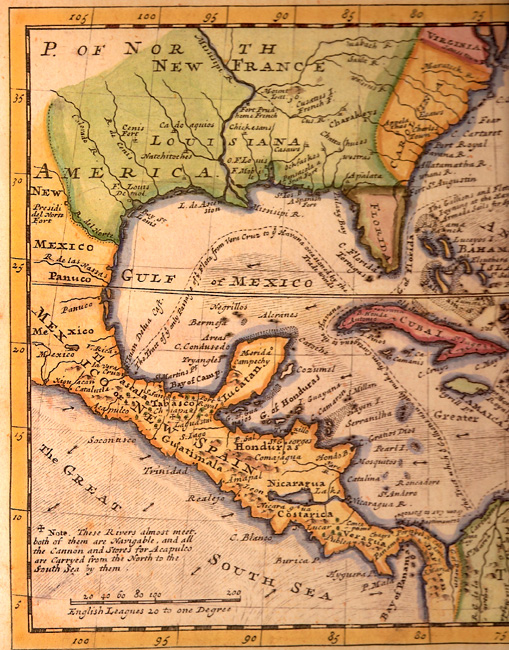
Comments: Notice especially the special interest the map would have been to English pirates in the early 18th century. Notice also that the only place named on the peninsula of Florida is "Fort St. Augustin." There are three dotted lines on this map, one in the Caribbean, one in the Gulf of Mexico, and one through the Florida Straits. All three meet at La Habana, which the English map calls "the Havana." The dotted line that begins in the lower right shows a sea course from Cartagena (Colombia) to La Habana; the script on this line says: "The Tract which the Gallions usually make from Cartagena to the Havana." The script on the line that starts at Veracruz on the Mexico Gulf coast says: "The Tract of the only Passage of the Flota from Vera Cruz to the Havana occasioned by the Trade Winds." And the dotted line that leaves the north coast of Cuba at Havana and follows what the unidentified English cartographer calls the "G of Florida" says this: "The Gallions and Flota usually Joyning at the Havana and the whole Armada Sails for Spain thro this Gulf." In addition to many more fascinating details on this map, the "Note" at the bottom left, referring to Acapulco, says: "These Rivers almost meet, both of them are Navigable, and all the Cannon and Stores for Acapulco are Carryed from the North to the South Sea by them."
For the right side of this map, see: => West Indies Map B.