Source: WTL drawing.
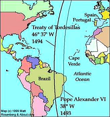
Comments: This map is not drawn to scale, but rather the Western Hemisphere has been pushed closer to Africa and Europe in order to show roughly where the two lines of demarcation cut across the eastern tip of South America. The Catholic Pope at the time (Alexander VI—a Spaniard) issued a legal decision (papal bull) titled Inter caetera (Among Other Things) adjudicating between Spain and Portugal the right to claim newly discovered lands (i.e., by Columbus in 1492). This decree was issued in 1493, and it gave Portugal a legal right (i.e., according to the Catholic Church) to lands 100 leagues west and south of Portugal's Azores Islands (see the line to the right on the map above). When Portugal complained to the pope that the original demarcation granted them too little land, a new treaty between Spain and Portugal was negotiated at the city of Tordesillas in northern Spain. Accordingly, the line was moved another 40 leagues westward (see the line to the left on the map above), favoring Portugal's claims in the New World. This agreement is known as the Treaty of Tordesillas (1494). Also notice, significantly, that the pope gave no other European country any legal or papal "right" to colonize the Americas. France, first, and England, later, would dispute the legal language of the pope's bull "Inter Caetera." To view a few images of the city of Tordesillas, see: => Tordesillas City Index.